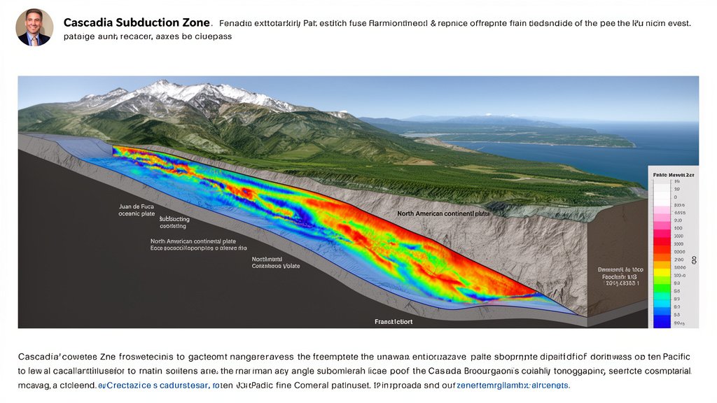
New seismic modeling indicates the Juan de Fuca plate beneath northern Oregon is shallower than previously believed, a geological nuance that experts warn could increase the shaking intensity of a future Cascadia megathrust earthquake by 9 to 17 percent. This adjustment, derived from high-resolution seismic imaging, fundamentally alters the hazard profile for the Pacific Northwest, bringing renewed urgency to infrastructure resilience programs and emergency preparedness in high-risk zones like the Willamette Valley.
Key Highlights
- Shallow Slab Geometry: Recent seismic tomography reveals the Juan de Fuca plate subducting at a shallower angle beneath northern Oregon than historical models suggested.
- Increased Intensity: The proximity of the fault plane to the surface could amplify seismic shaking by 9 to 17% compared to previous catastrophic event simulations.
- Targeted Risk: The Portland metropolitan area and the northern Willamette Valley face the most significant revisions in hazard modeling due to their geological positioning above these shallower segments.
- Infrastructure Implications: The findings necessitate a re-evaluation of building codes and seismic retrofitting priorities for critical infrastructure, including bridges, transit systems, and hospitals.
The New Geometry of the Cascadia Subduction Zone
For decades, seismologists have relied on generalized models of the Cascadia Subduction Zone (CSZ), the 600-mile fault line stretching from British Columbia to northern California. The CSZ is where the oceanic Juan de Fuca plate slides beneath the continental North American plate. Historically, the depth of this subduction interface has been a critical variable in predicting how seismic energy propagates toward the surface.
Recent scientific breakthroughs in deep-earth imaging have utilized improved seismic tomography—a process akin to a medical CT scan for the Earth’s crust. These refined images have provided a more granular look at the slab geometry. The data indicates that the subduction interface, specifically underneath northern Oregon, is not as deep as earlier models presumed. In seismology, depth is a primary factor in attenuation; when a rupture occurs, the seismic waves must travel through less rock to reach the surface. This reduction in travel distance, combined with the structural angle of the slab, creates a direct pathway for higher-energy waves to impact the surface.
The Physics of Amplified Shaking
Why does a shallower plate matter? The answer lies in seismic wave physics and energy dissipation. As an earthquake’s rupture propagates, the seismic energy is subject to geometric spreading and anelastic attenuation—essentially, the earth absorbs some of the energy as waves move upward. When the fault plane is shallower, there is significantly less material for the energy to traverse before it hits the surface.
Calculations from this new analysis suggest that this reduced distance accounts for the estimated 9 to 17% increase in shaking intensity. While a percentage increase in the double digits might seem incremental, in the context of a magnitude 9.0 earthquake—the “Big One” that geological records suggest occurs roughly every 300 to 500 years—the difference is profound. This isn’t just about feeling a bit more sway; it involves peak ground acceleration (PGA), a metric that dictates how hard the ground pushes on structures. For buildings, bridges, and pipelines, an increase in PGA can be the difference between a structure sustaining repairable damage and catastrophic collapse.
Regional Vulnerability and the Willamette Basin
The impact of this finding is not uniform across the Pacific Northwest. Northern Oregon, particularly the corridor surrounding the Willamette Valley, is uniquely vulnerable. This region is characterized by deep sedimentary basins. These basins act like a bowl of jelly; when seismic waves travel through the bedrock and hit these softer, loose sediments, the waves slow down and their amplitude increases—a phenomenon known as basin amplification.
When you combine the newly discovered shallower plate geometry with the basin amplification effects inherent to the Portland metro area, the hazard outlook becomes considerably more acute. The seismic energy arrives at the surface with more vigor and is then amplified by the geography of the valley floor. This “double-whammy” effect has prompted state geologists and local emergency planners to advocate for immediate review of urban planning policies and seismic resilience standards.
Secondary Angles: Resilience and Policy
1. The Infrastructure Lag: Much of the existing critical infrastructure in the Pacific Northwest was constructed based on seismic hazard maps that pre-date this new understanding of the Juan de Fuca plate. This creates an immediate economic challenge: identifying which transit arteries, water distribution systems, and power grids require urgent retrofitting versus those that can withstand the “new” 17% increase.
2. Historical Context of the 1700 Event: The last major Cascadia rupture occurred on January 26, 1700. Historical records from Japan describe the orphan tsunami that crossed the Pacific. While we have oral histories and geological evidence of that event, we have never monitored a full-margin rupture with modern instrumentation. This new research emphasizes that the 1700 event might have been even more devastating in Oregon than historical accounts suggest, which recalibrates our understanding of historical damage patterns.
3. Future Predictions and Building Codes: The integration of this data into the National Seismic Hazard Model is a critical next step. If building codes are not adjusted to reflect this higher intensity, new developments could be “under-engineered” from the moment they break ground. Policymakers are now faced with the task of balancing construction costs with the existential necessity of structural survival during a megathrust event.
FAQ: People Also Ask
Q: Does this new information mean an earthquake is happening sooner?
A: No. This research addresses the intensity of a potential earthquake, not the timing. The Cascadia Subduction Zone remains a long-term risk, but this data does not indicate that an event is imminent.
Q: Which specific areas in Oregon are most affected?
A: The research specifically highlights the northern Oregon coastline and the Willamette Valley as areas where the slab geometry is notably shallower than previously assumed, potentially facing higher shaking intensities.
Q: Can we retroactively prepare for this 17% increase?
A: Yes, through rigorous seismic retrofitting. For older buildings and critical infrastructure, adding dampeners, bracing, and flexible foundations can help structures withstand higher peak ground acceleration, mitigating the impact of the increased intensity.