The Pacific Northwest, a region typically defined by its lush greenery and reliable moisture, is confronting a stark reality this year. According to the latest seasonal outlook from the National Oceanic and Atmospheric Administration (NOAA) and the National Weather Service (NWS), the region is poised for a hotter and drier outlook that extends through the remainder of 2026. This forecast, which offers little relief for drought-stricken areas in Washington, Oregon, and Idaho, signals a troubling continuation of climatic volatility that threatens water security, agricultural viability, and forest health across the Cascades and beyond.
Key Highlights
- Record Deficits: Snowpack levels across the Pacific Northwest have plummeted to roughly one-third of their historical normal, leaving a critical “reservoir” of water effectively empty.
- El Niño Transition: Meteorologists are tracking a likely shift toward El Niño conditions by mid-2026, a phenomenon historically linked to warmer, drier weather in the region.
- Statewide Emergencies: Multiple counties in Oregon and Washington have already declared drought emergencies months earlier than in previous years, triggering preemptive state-level support.
- Fire Risk Escalation: With soil moisture at record lows and vegetation drying out prematurely, emergency managers are bracing for an expanded and aggressive wildfire season.
- Agricultural Crisis: Farmers in basins like the Klamath are anticipating severe water restrictions, threatening crop yields and economic stability for the regional agricultural sector.
The Meteorological Breakdown: A Region in Transition
The climate outlook for the Pacific Northwest is not merely a short-term weather anomaly; it is the manifestation of a complex interplay between local environmental conditions and global climate drivers. At the heart of this forecast is the transition out of La Niña conditions, which characterized much of the winter, toward a neutral phase and eventually an encroaching El Niño pattern.
The Role of ENSO and Ocean Temperatures
The El Niño-Southern Oscillation (ENSO) is a critical factor. Sea-surface temperatures along the equator are currently demonstrating the potential to warm significantly. This warming is the engine that drives regional weather changes thousands of miles away. As these waters heat up, they alter atmospheric jet streams, often steering storm tracks away from the Pacific Northwest and locking in high-pressure “ridging” over the Western United States. This ridge acts as a thermal blanket, trapping heat and preventing the moisture-rich frontal systems that usually sustain the region’s hydrology. Scientists at the Climate Prediction Center suggest that this El Niño influence could manifest as early as late spring, persisting through the end of the year, potentially escalating into a strong or even “very strong” event.
Why Snowpack is the Primary Indicator
While temperature is the headline, snowpack is the true casualty of this season. In the Pacific Northwest, mountain snow serves as the natural water tower of the region. It accumulates during the winter months and melts slowly during the spring and summer, providing a steady, reliable flow of water for rivers, streams, and reservoirs. This year, the snowpack failed to build adequately. Due to a winter that tied 1934 as the warmest on record for parts of the region, precipitation fell primarily as rain rather than snow, or failed to materialize at all. This lack of accumulation means the region is operating on a deficit before the hottest months even begin. Without the thermal mass of the snowpack to moderate temperatures and maintain base flow in river systems, the ecosystem is highly vulnerable to rapid heating.
Economic and Environmental Implications
The ripple effects of this forecast are profound, touching almost every facet of life in the Pacific Northwest. From the energy sector to local food production, the impact of a warm, dry 2026 is already being felt.
Agricultural Vulnerability and Irrigation
For the agricultural industry, water is the primary currency. In basins such as the Klamath, where water rights are already a contentious issue, the outlook is grim. Farmers are bracing for severe curtailments, which could lead to reduced planting, crop failure, and a significant economic downturn for rural communities. The soil moisture deficit, exacerbated by the lack of spring runoff, means that fields will require more irrigation earlier in the season, further straining already limited groundwater supplies.
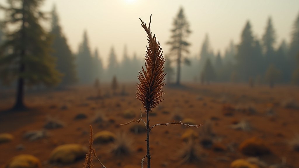
Fire Season and Public Safety
The prospect of an extended wildfire season is perhaps the most immediate public safety concern. When the landscape dries out in April and May, it creates a prolonged fuel availability window. Vegetation that would usually remain lush and fire-resistant well into July is already beginning to dry out. This shift necessitates a change in how fire agencies prepare for the summer. Resources that might usually be allocated for later in the year are being shifted to early-season readiness. Furthermore, the combination of dry forests and expected heat waves creates the perfect storm for rapid fire spread, increasing the risk to wildland-urban interfaces across the region.
Hydropower and Energy Demand
The Pacific Northwest relies heavily on hydropower for its electricity grid. Low water levels in reservoirs mean that the capability of major dams to generate power is diminished. As temperatures rise, the demand for air conditioning and cooling infrastructure increases, creating a stress test for the regional grid. This potential for supply-demand imbalance forces utilities to reconsider their peak load management strategies, potentially leading to higher costs for consumers or the need to bring more expensive, less sustainable energy sources online during peak heat events.
Historical Context and Future Predictions
Comparing 2026 to historical milestones reveals a sobering trend. State climatologists and researchers are drawing strong parallels between the current year and 2015, a year remembered for severe drought and the near-emptying of critical reservoirs like Detroit Lake. The recurrence of such events suggests that the “new normal” is defined by volatility.
The Long-Term Climate Trend
While any single year can be influenced by natural variability, the frequency of these “warm and dry” summers is increasing. Data from Washington State shows that four of the past five summers have ranked among the hottest since records began in 1895. This is not just a cycle; it is a trend line. The warming of the Pacific Ocean, combined with shifts in global atmospheric patterns, suggests that the Pacific Northwest must adapt its infrastructure—from water storage systems to forest management practices—to a future where water is less abundant and heat is more persistent.
Adapting to the Drought Economy
Policy makers are already acting. The declaration of drought emergencies in Washington and Oregon is a proactive measure designed to unlock funding for drought mitigation and assist local communities in managing water allocations. However, long-term adaptation will require more than just emergency declarations. It will require investments in water efficiency, resilient agricultural practices, and aggressive forest management to reduce the intensity of potential wildfires. The 2026 forecast is a warning, an opportunity for the region to address its vulnerabilities before the heat of summer takes full hold.
FAQ: People Also Ask
1. What is the difference between this year’s drought and previous years?
This year’s drought is distinguished by an exceptionally low snowpack—roughly one-third of normal—and an early start to dry conditions. The combination of a record-warm winter and the rapid onset of dry spring weather has left reservoirs and soils significantly more depleted than in 2024 or 2025.
2. How does the transition to El Niño affect the Pacific Northwest?
Historically, an El Niño phase is associated with warmer and drier weather in the Pacific Northwest. While ENSO (El Niño-Southern Oscillation) typically has a stronger impact in the winter, the shift to El Niño in 2026 is expected to influence atmospheric ridging, which discourages the arrival of moisture-laden weather systems and promotes high-pressure heat domes.
3. Is there any chance for conditions to improve?
While unexpected late-spring storms can provide temporary moisture, the overarching climate outlook for the remainder of the year is for persistent warmth and below-average precipitation. Meteorologists indicate that the probability of significant drought relief is low given the current ocean temperature trends and established atmospheric patterns.
4. What should residents do to prepare for the wildfire season?
Residents are encouraged to create defensible space around their properties, ensure they have an emergency evacuation kit ready, and stay informed via local emergency alert systems. Given the early dry conditions, fire prevention precautions should be taken much earlier in the season than usual.